
Overview
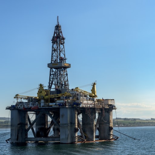
Motivation for this Phase 1 project stemmed from the advancement of offshore oil and gas operations into extreme offshore environments that are often remote, environmentally sensitive, and economically challenging. The lessons learned from Hurricanes Rita and Katrina and the 2010 Deepwater Horizon oil spill in the Gulf of Mexico were also impetuses for the development of this project. These events highlighted the need for improved models, data, and tools to identify knowledge and technology gaps with offshore hydrocarbon exploration and production systems to help prevent future spills and provide predictions for a range of end-users. This project focused on developing an integrated modeling and data system from the subsurface to the shore, including evaluation of potential risks and identification of knowledge and technology gaps to inform offshore spill prevention efforts. It has continued into Phase 2 as Geohazard and Subsurface Uncertainty Modeling.
Approach
This project provided data, tools, and techniques to evaluate the potential risks and identify possible knowledge and technology gaps in the offshore system using science-based, data-driven assessments. The tools and techniques leveraged advanced big data science and computing to innovate and advance the understanding of spatial and temporal behaviors and relationships for engineered-natural, multi-variate systems. These products can support the analysis of subsurface, wellbore, and water column to evaluate relationships, trends, risks of offshore spills, and uncertainty.
Researchers developed a new multi-component model, the Offshore Risk Model (ORM), which ties the subsurface, wellbore, and water column into an integrated assessment model. ORM relies on the synthesis of data—from the subsurface to the shore—to develop innovative tools and approaches to drive analyses that effectively evaluate and reduce risks associated with extreme offshore hydrocarbon development.
Data have been collected and integrated into NETL’s Energy Data eXchange (EDX), providing a single point of discovery and access. Since the start of this project, over 6 terabytes of data have been collected and incorporated into EDX. Along with discovery and access to these data via EDX, users can visualize data using GeoCube, a custom web-based mapping application. GeoCube supports basic spatial and temporal analysis, allowing users to quickly identify overall trends and patterns in the data, as well as share these discoveries with others using various export functions (print, snapshot, and extract data). In addition, these data have been used to develop five science-based, data-driven tools and models for the ORM to support the evaluation and reduction of risks and uncertainty associated with extreme offshore hydrocarbon development. These five tools and models address concerns from the subsurface, wellbore, and water column to evaluate relationships, trends, risks of offshore spills, and uncertainty. The tools are:
- Subsurface Trend Analysis (STA)—a data-driven approach for improving geologic knowledge and reducing subsurface uncertainty;
- Blowout and Spill Occurrence Model (BLOSOM)—a 4D fate and transport model for simulating oil spills to support spill prevention and provide a greater understanding of how hydrocarbon leaks from all sources are transported throughout offshore systems;
- Cumulative Spatial Impact Layers (CSIL)—a spatial-temporal approach for rapidly quantifying potential impacts;
- Spatially Weighted Impact Model (SWIM)—a decision support tool driven by multi-variate relationship models and user-defined weights; and
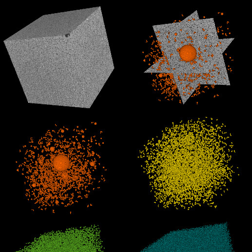
- Variable Grid Method (VGM)—an approach for quantifying and visualizing uncertainty associated with spatial data. The VGM is pictured below.
Outcomes
Research Products
For a video overview of the ORM suite, please see: https://youtu.be/iN1REKcfXxQ.
A geospatial evaluation of oil spill impact potential on coastal tourism in the Gulf of Mexico
Computers, Environment and Urban Systems 2018, 68, 26–36
Nelson, J. R.; Grubesic, T. H.; Sim, L.; Rose, K.
March 2018
https://www.sciencedirect.com/science/article/pii/S0198971516304318?via%3Dihub
Choose Your Own Adventure: NETL’s Innovative Cumulative Spatial Impact Layers Tool for Processing, Analyzing, and Visualizing Spatio-Temporal Big Data
Presented at the Ocean Sciences Meeting, Portland, OR, Feb 11–16, 2018.
Romeo, L.; Wingo, P.; Barkhurst, A.; Chittum, J.; Bauer, J.; Rose, K.
Turning the data deluge into insights for decisions using NETL’s Spatially Weighted Impact Model
Presented at the Ocean Sciences Meeting, Portland, OR, Feb 11–16, 2018.
Bauer, J.; Romeo, L.; Nelson, J.; Wingo, P.; Bunn, A.; Barkhurst, A.; Chittum, J.; Rose, K.
Dispersant Application Simulation with BLOSOM
Presented at the Gulf of Mexico Oil Spill and Ecosystem Sciences Conference, New Orleans, LA, Feb 5–8, 2018.
Wingo, P.; Duran, R.; Vielma, J.; Burgess, W.; Rose, K.
Swimming through the data deluge to inform oil spill prevention needs
Presented at the Gulf of Mexico Oil Spill and Ecosystem Science Conference, New Orleans, LA, Feb 5–8, 2018.
Bauer, J.; Romeo, L.; Nelson, J.; Wingo, P.; Bunn, A.; Barkhurst, A.; Chittum, J.; Rose, K.
Cumulative Spatial Impact Layers – Choose Your Own Adventure: NETL’s Innovative Tool for Processing, Analyzing, and Visualizing Spatio-Temporal Data
Presented at the Computational Geosciences Meeting, NETL Albany, OR, Jan 2018.
Romeo, L.; Wingo, P.; Justman, D.; Barkhurst, A.; Bauer, J.; Rose, K.
Working Smarter Not Harder – Developing a Virtual Subsurface Data Framework for US Energy R&D
Invited presentation at the American Geophysical Union Annual Meeting, Dec 11–15, 2017.
Rose, K.; Baker, D.V.; Bauer, J.; Dehlin, M.; Jones, T. J.; Rowan, C.
Quasi-Steady Structures Organizing Lagrangian Transport
Instituto de Ciencias del Mar, Departamento de Oceanografıa Fısica. Barcelona, Spain, November 2017.
Duran, R.
Reducing Uncertainty in the Subsurface: Applying the Subsurface Trend Analysis method to refine subsurface property predictions in the Gulf of Mexico
Presented at the Geological Society of America Annual Meeting, Oct 22–25, 2017.
Mark-Moser, M.; Rose, K.; Miller, R.; Bauer, J.; Cameron, E.
Blowout & Spill Occurrence Model (BLOSOM)
Sim L., Vielma J., Duran R., Romeo R., Wingo P., and K, Rose.
BLOSOM – release. United States: N. p., 2017. Web. doi:10.18141/1420083.
https://edx.netl.doe.gov/dataset/blosom-release
Variable Grid Method (VGM)
Technology Transfer
U.S. 14/619,501
2017
https://edx.netl.doe.gov/vgm/
A New, Generalized Approach to Risk Maps for the Gulf of Mexico
Gulf of Mexico Oil Spill & Ecosystem Science Conference, New Orleans, LA, Feb 6-9, 2017.
Duran, R., Beron-Vera, J., Olascoaga, J., Romeo, L., Rose, K., Bauer, J., and Nelson, J.
Sub-Grid Parameterizations for Oceanic Oil-Spill Simulations
NETL-TRS-9-2016; EPAct Technical Report Series; U.S. Department of Energy, National Energy Technology Laboratory: Albany, OR, 2016; p 36.
Duran, R.
June 2016
https://edx.netl.doe.gov/dataset/sub-grid-parameterizations-for-oceanic-oil-spill-simulations
Spatially Weighted Impact Model: evaluating management scenarios
Presented at the Esri User Conference, San Diego, CA, June 27–July 1, 2016.
Romeo, L.; Bauer, J.; Dick, D.; Nelson, J.; Rose, K.
Big data and spatio-temporal approaches for multivariate analysis
Presented at the Esri User Conference, San Diego, CA, June 27–July 1, 2016.
Bauer, J. R.; Rose, K.; Vasylkivska, V.; Justman, D.; Glosser, D.; Miller, R.; Baker, D. V.
Geospatial Approaches & Tools Designed for Offshore Oil Spill Planning & Preparedness
Presented at the Clean Pacific Conference, Seattle, WA, June 21–23, 2016.
Romeo, L.; Bauer, J.; Dick, D.; Nelson, J.; Rose, K.; Vielma, J.; Bunn, A.; Duran-Sesin, R.; Coleman, A.
Transport in the Gulf of Mexico
AmeriMech Symposium on Fluid Transport and Nonlinear Dynamics. Woods Hole May 17-20, 2016.
Duran, R. F.J. Beron-Vera, M. J. Olascoaga.
Brown shrimp (Farfantepenaeus aztecus) density distribution in the Northern Gulf of Mexico: An approach using boosted regression trees
Fisheries Oceanography. 25. 337-348.
Montero, Jose & A. Chesney, Tanya & R. Bauer, Jennifer & Froeschke, John & Graham, Jim. (2016)
March 2016
https://doi.org/10.1111/fog.12156
A multi-variate geospatial approach to constrain subsurface properties and reduce uncertainty
Presented at the CoDA Conference, Santa Fe, MN, Mar 2–4, 2016.
Rose, K.
Analyzing multisource and multidimensional data to evaluate spatio-temporal trends and patterns of potential impacts related to modelled offshore hazards
Presented at the CoDA Conference, Santa Fe, MN, Mar 2–4, 2016.
Bauer, J.; Rose, K.; Romeo, L.; Nelson, J.; Dick, D.
Innovating beyond today’s GIS, advanced tools and analysis for energy-geosystems
Presented at the Esri Federal GIS Conference & Developers Summit, Washington, DC, Feb 24–26, 2016.
Rose, K.; Bauer, J. M.; Baker, D.V.; Miller III, R.; Vasylkivska, V.
Acquisition, processing, and visualization of big data as applied to robust multivariate impact models
Presented at the American Geophysical Union: Ocean Sciences Meeting, New Orleans, LA, Feb 21–26, 2016.
Romeo, L.; Bauer, J.; Dick, D.; Nelson, J.; Rose, K.; Bunn, A.; Buenau, K.; Coleman, A.
Leveraging multidisciplinary data & research to develop spatio-temporal risk assessment and decision support tools for evaluating offshore hazards
Presented at the Ocean Science Meeting, New Orleans, LA, Feb 21–26, 2016.
Bauer, J. R.; Rose, K.; Romeo, L.; Nelson, J.; Dick, D.; Sim, L.
The Variable Grid Method, an Approach for the Simultaneous Visualization and Assessment of Spatial Trends and Uncertainty
Presented at the American Geophysical Union Fall Meeting, Dec 14–18, 2015.
Glosser, D.; Bauer, J. R.; Rose, K.; Barkhurst, A.
Spatial decision support tools combining GIS for Oil Spill Preparedness & Marine Spatial Planning
Presented at the Esri Ocean GIS Forum, Redlands, CA, Nov 4–6, 2015.
Bauer, J. R.; Rose, K.
Explore research products that are related to this project.
See related Phase 2 projects.

*Image Source: NETL, 2018
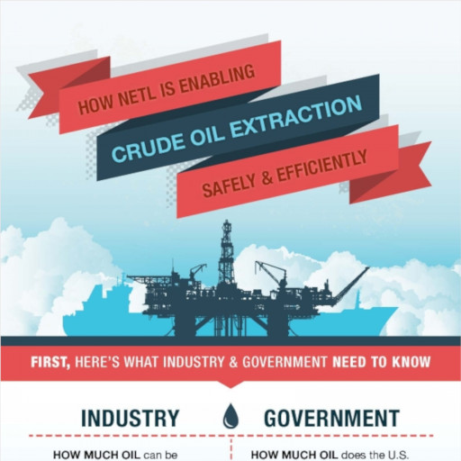
Infographic on critical components and value added from the Offshore Risk Modeling Suite.
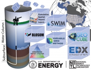
*Image Source: NETL
The Offshore Risk Modeling (ORM) suite offers tools that address the entire offshore system (from the subsurface and wellbore, through water column, to the sea surface and coastline). To date, the ORM also provides terabytes of data for federal waters in the Gulf of Mexico, and offshore California and Alaska to drive all the ORM tools, models, and analytics.

*Image Source: NETL
Example oil spill forecast (dark gray- black tones) and possible socio-economic and environmental impacts (green – red tones) outputs from both data and tools, specifically the BLOSOM, CSIL, and SWIM models, that make up the Offshore Risk Modeling suite. These integrated outputs offer critical data reduce risks and cost associated with offshore exploration and production.
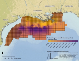
*Image Source: NETL
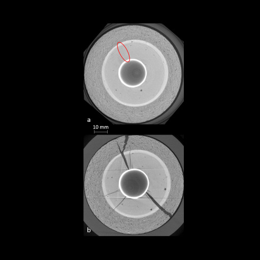
Subsurface pressure gradient, developed using data and the STA and VGM from the Offshore Risk Modeling Suite. Together, STA and VGM offer and improved prediction of subsurface pressure gradients in the offshore Gulf of Mexico, include for regions with little to no data; provide novel insights that can improve resource estimates, increase profitability, and reduce geohazards.
Contacts
Kelly Rose
Principal Investigator
Offshore Portfolio Lead
Jennifer Bauer
Co-Principal Investigator
Alexandra Hakala
Senior Fellow (Detail)
Geological & Environmental Systems
Roy Long
Offshore Portfolio Technical Manager
Effective Resource Development
Philip Reppert
Associate Director
Geological & Environmental Systems