EDX Metadata Standards Guidance
What is metadata?
Metadata is informational data about your dataset that allows for data discovery, searchability, management, that identifies attributes of the information it describes. This includes properties, history, origin, versions, and other information, used primarily for tracking, classification, and analysis. Provides essential information to improve the efficiency of sample tracking and makes sample data more findable, accessible, interoperable, and reusable (FAIR).
Functions of metadata include:
- Organization and description
- Discovery and searchability
- Utilization and preservation
- Information creation, multi-versioning, and reuse
- Facilitating interoperability

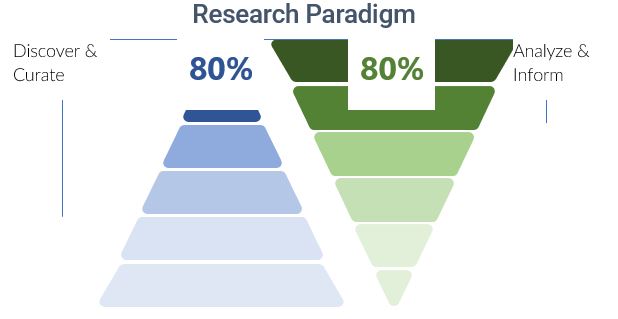
EDX aims to invert this pyramid by making curated data available – allowing researchers to spend more time on research and effectively learn from and build upon past data. Detailed metadata allows for researchers to effectively find this data and contributes to the goal of EDX.
How should I get started in creating metadata?
Metadata is an additional resource, such as a json, xml, or other text file., attached to the EDX submission. To get started with assembling your metadata, USGS provides documentation to ensure your metadata is informative and complete:
Suggested metadata standard guidance
Once you’ve compiled the data for your metadata file, the guidance in the table below can be used to assemble your data into the proper format and inform you on other potential data that may be required.
Disclaimer: Metadata standards and guidance are often updated. Please check back to this table and corresponding links to get the most up-to-date recommendations.
| Type of Data | Description | Link to Recommended Metadata Standard |
|---|---|---|
| General Earth Observation Data Standard | Standard used by U.S. Government that is defined as Earth-Observation Data per the Common Framework for Earth-Observation Data released 2016. | DCAT-US Schema v1.1 (Project Open Data Metadata Schema) | resources.data.gov |
| Geospatial | Data associated with GIS. Required per the Geospatial Data Act of 2018 via the Federal Geographic Data committee (FGDC). | Geospatial Metadata Standards and Guidelines — Federal Geographic Data Committee (fgdc.gov) |
Other Metadata Resources
Metadata and describing data – Cornell Data Services
Preparing FAIR data for reuse and reproducibility – Cornell Data Services
Citation Resources
EDX published submissions include a data citation to ensure the appropriate use/reuse of the data. A data citation template is provided for each data submission that adheres to the Joint Declaration of Data Citation Principles (JDDCP). Users are encouraged, but not required to use the data citation template. An example of this format is found below and the link to the articles will provide more in-depth information regarding data citations. Submissions that apply for an OSTI DOI will have the DOI number appended to the data citation making the submission more discoverable in other search repositories such as data.gov, osti.gov, Google Scholar and others.
Citation References
A data citation roadmap for scientific publishers
https://www.nature.com/articles/sdata2018259
Citation Example
Cousijn, H., Kenall, A., Ganley, E. et al. A data citation roadmap for scientific publishers. Sci Data 5, 180259 (2018). https://doi.org/10.1038/sdata.2018.259
Journal Production Guidance for Software and Data Citations
https://www.nature.com/articles/s41597-023-02491-7
Stall, S., Bilder, G., Cannon, M. et al. Journal Production Guidance for Software and Data Citations. Sci Data 10, 656 (2023). https://doi.org/10.1038/s41597-023-02491-7
External Resources
External Citation Guidance
EDX adheres to Federal and International data guidelines and best practices where applicable. The links below align with EDX Data governance and can provide further information on data and software citation best practices.
The Joint Declaration of Data Citation Principles from FORCE11


