-
Our collection of data is primarily GIS and geospatially oriented but our tool will help you find other assets including databases, applications and much more. With the new...
-
Dataset Size: 0 bytes
Resource List
View within Submission Gathering Resources...
 -
-
NETLNational Energy Technology Laboratory’s (NETL) GEO Water Energy Link Library, geoWELL, is a map-based application that provides quick access to the primary on-line sources of...
-
Dataset Size: 0 bytes
Resource List
View within Submission
Gathering Resources... -
-
A comprehensive list of data, tools, and maps from EIA.
-
Dataset Size: 0 bytes
Resource List
View within Submission
Gathering Resources... -
-
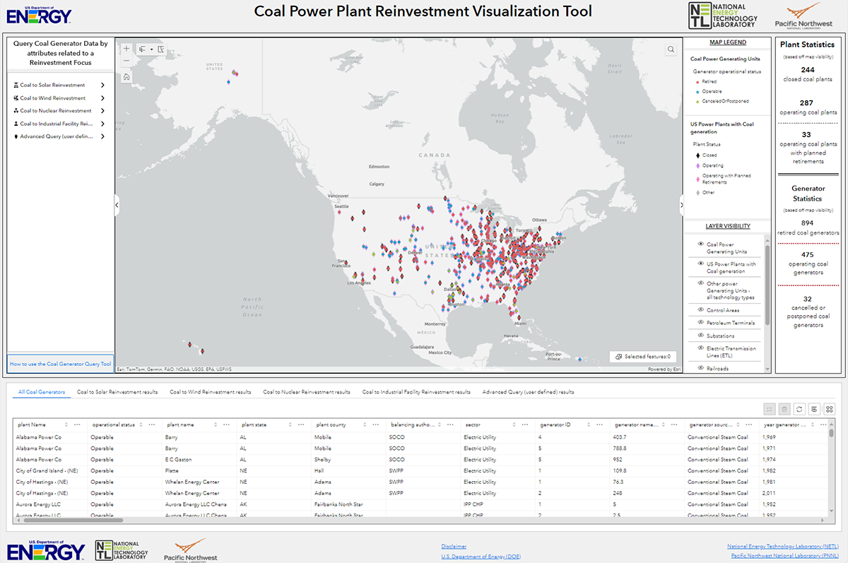
Geospatial NETLThis tool, available at https://energycommunities.gov/coal-power-plant-reinvestment-visualization-tool/, serves as a public database and map for the purposes of enabling state...
-
Dataset Size: 0 bytes
Resource List
View within Submission
Gathering Resources... -
-
Geospatial NETLThe Energy Community Atlas provides efficient access to authoritative, curated, and relevant data that is vital to supporting energy planning, development, and economic growth...
-
Dataset Size: 850.401 MB
Resource List
View within Submission
Gathering Resources... -
-
Geospatial NETLAn ArcGIS Story Map that provides context and understanding of unconventional critical mineral resource potential.
-
Dataset Size: 0 bytes
Resource List
View within Submission
Gathering Resources... -
-
Geospatial NETLThis submission contains a zip file with the developed Global Oil & Gas Features Database (as an ArcGIS geodatabase). Access the technical report describing how this...
-
Dataset Size: 1.374 GB
Resource List
View within Submission
Gathering Resources... -
-
GeospatialSocial vulnerability refers to the potential negative effects on communities caused by external stresses on human health. Such stresses include natural or human-caused...
-
Dataset Size: 0 bytes
Resource List
View within Submission
Gathering Resources... -
-
Geospatial NETLThe Critical Minerals (CM) Data Dashboard provides data-driven insights to help unlock the potential of conventional and unconventional CM resources in the United States. The...
-
Dataset Size: 0 bytes
Resource List
View within Submission
Gathering Resources... -
-
Geospatial NETLNOTICE: Geocube has been replaced by EDX Spatial, a modern geospatial platform to map, visualize, query and explore spatial data. Online web mapping tool for visualization and...
-
Dataset Size: 0 bytes
Resource List
View within Submission
Gathering Resources... -
-
Geospatial NETLThe NEWTS (National Energy Water Treatment and Speciation) database dashboard displays sites across the nation where energy-related wastewater stream samples and composition...
-
Dataset Size: 0 bytes
Resource List
View within Submission
Gathering Resources... -
-
Geospatial NETLThe Offshore Geological Carbon Storage Inventory Web Map is an online web mapping application designed to help users explore and visualize the Offshore Geologic Carbon Storage...
-
Dataset Size: 446.734 KB
Resource List
View within Submission
Gathering Resources... -
-
Geospatial NETLData, geospatial data resources, and the linked mapping tool and web services reflect data for two types of potentially qualifying energy communities: 1) Census tracts and...
-
Dataset Size: 231.811 MB
Resource List
View within Submission
Gathering Resources... -
-
Geospatial NETLThe Wellbore Exploration and Location Logistic System (WELLS) Interactive Application is an interactive tool to enable easy exploration and visualization of the living national...
-
Dataset Size: 0 bytes
Resource List
View within Submission
Gathering Resources... -
-
Geospatial NETLThe Mapping Inquiry Tool (MapIT) database consists of a geodatabase and data catalog of geologic, geophysical, structural, hydrologic, and contextual data, based on the data...
-
Dataset Size: 23.385 GB
Resource List
View within Submission
Gathering Resources... -