-
SimCCS is a software platform for carbon capture and storage (CCS) infrastructure design. SimCCS is an economic-engineering software tool for making integrated CCS...
-
Dataset Size: 0 bytes
Resource List
View within Submission Gathering Resources...
 -
-
NETLNational Energy Technology Laboratory’s (NETL) GEO Water Energy Link Library, geoWELL, is a map-based application that provides quick access to the primary on-line sources of...
-
Dataset Size: 0 bytes
Resource List
View within Submission
Gathering Resources... -
-
The National Carbon Sequestration Database (NATCARB) is a geographic information system (GIS)-based tool for viewing carbon capture, use and storage (CCUS) potential across the...
-
Dataset Size: 0 bytes
Resource List
View within Submission
Gathering Resources... -
-
NETLRaw data and processed relative permeability curves for brine and super-critical CO2 measurements. .
-
Dataset Size: 0 bytes
Resource List
View within Submission
Gathering Resources... -
-
MFiX (Multiphase Flow with Interphase Exchanges) is an open source, general-purpose computer code developed at NETL for describing the hydrodynamics, heat transfer and chemical...
-
Dataset Size: 0 bytes
Resource List
View within Submission
Gathering Resources... -
-
NETLLink to BLOSOM release download site
-
Dataset Size: 0 bytes
Resource List
View within Submission
Gathering Resources... -
-
BSEE works to promote safety, protect the environment, and conserve resources offshore through vigorous regulatory oversight and enforcement. Visit the top of our About BSEE...
-
Dataset Size: 0 bytes
Resource List
View within Submission
Gathering Resources... -
-
The WVU Log Viewer allows users to display well files.
-
Dataset Size: 0 bytes
Resource List
View within Submission
Gathering Resources... -
-
A comprehensive list of data, tools, and maps from EIA.
-
Dataset Size: 0 bytes
Resource List
View within Submission
Gathering Resources... -
-
NETLSTA Tool – a virtual research assistant designed to: • Organize and visualize disparate big data and knowledge resources • Simplify geologic domain formation • Provide and...
-
Dataset Size: 1.244 GB
Resource List
View within Submission
Gathering Resources... -
-
NETLThe injection of CO2 into subsurface formations causes an increase in pore pressure. This alters the state of stress in ways that can lead to activation of faults and unintended...
-
Dataset Size: 925.987 MB
Resource List
View within Submission
Gathering Resources... -
-
NETLDesigns for Risk Evaluation and Management, or DREAM, is a tool that generates and optimizes monitoring programs for detecting potential leaks from geological carbon storage....
-
Dataset Size: 0 bytes
Resource List
View within Submission
Gathering Resources... -
-
NETLNote: This is the last version (a2.6.1) of NRAP-Open-IAM released during NRAP Phase II in 2022. The latest version of NRAP-Open-IAM is available here:...
-
Dataset Size: 1,010.967 MB
Resource List
View within Submission
Gathering Resources... -
-
NETLThe Offshore CO2 Saline Storage Calculator is a data-driven tool that applies the adapted DOE CO2 Methodology to calculate all potential distributions of offshore storage...
-
Dataset Size: 0 bytes
Resource List
View within Submission
Gathering Resources... -
-
NETLThe FE/NETL CO2 Saline Storage Cost Model estimates costs to store a tonne of CO2 in a saline reservoir. The model estimates costs associated with a project, using simplified...
-
Dataset Size: 35.868 MB
Resource List
View within Submission
Gathering Resources... -
-
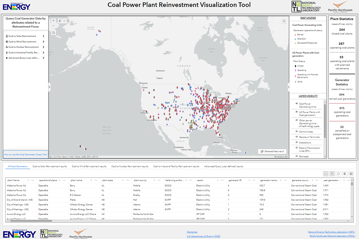
Geospatial NETLThis tool, available at https://energycommunities.gov/coal-power-plant-reinvestment-visualization-tool/, serves as a public database and map for the purposes of enabling state...
-
Dataset Size: 0 bytes
Resource List
View within Submission
Gathering Resources... -
-
Geospatial NETLThe Energy Community Atlas provides efficient access to authoritative, curated, and relevant data that is vital to supporting energy planning, development, and economic growth...
-
Dataset Size: 850.401 MB
Resource List
View within Submission
Gathering Resources... -
-
Geospatial NETLAn ArcGIS Story Map that provides context and understanding of unconventional critical mineral resource potential.
-
Dataset Size: 0 bytes
Resource List
View within Submission
Gathering Resources... -
-
AI/ML Geospatial NETLThe Advanced Infrastructure Integrity Model (AIIM) is a multivariate, multi-machine learning modeling technology applied to evaluate the integrity of offshore energy...
-
Dataset Size: 0 bytes
Resource List
View within Submission
Gathering Resources... -
-
NETLThis NRAP tool is for optimal design of microseismic monitoring network using surface or borehole geophones. User inputs include 1D/3D velocity models, the geophone distribution...
-
Dataset Size: 11.572 MB
Resource List
View within Submission
Gathering Resources... -