-
AI/ML Geospatial NETLEDX ClaiMM is a centralized data & analytical platform designed to revolutionize U.S. critical minerals and materials (CMM) activities. By providing a robust digital...
-
Dataset Size: 0 bytes
Resource List
View within Submission Gathering Resources...
 -
-
NETLThe FE/NETL CO2 Saline Storage Cost Model estimates costs to store a tonne of CO2 in a saline reservoir. The model estimates costs associated with a project, using simplified...
-
Dataset Size: 35.868 MB
Resource List
View within Submission
Gathering Resources... -
-
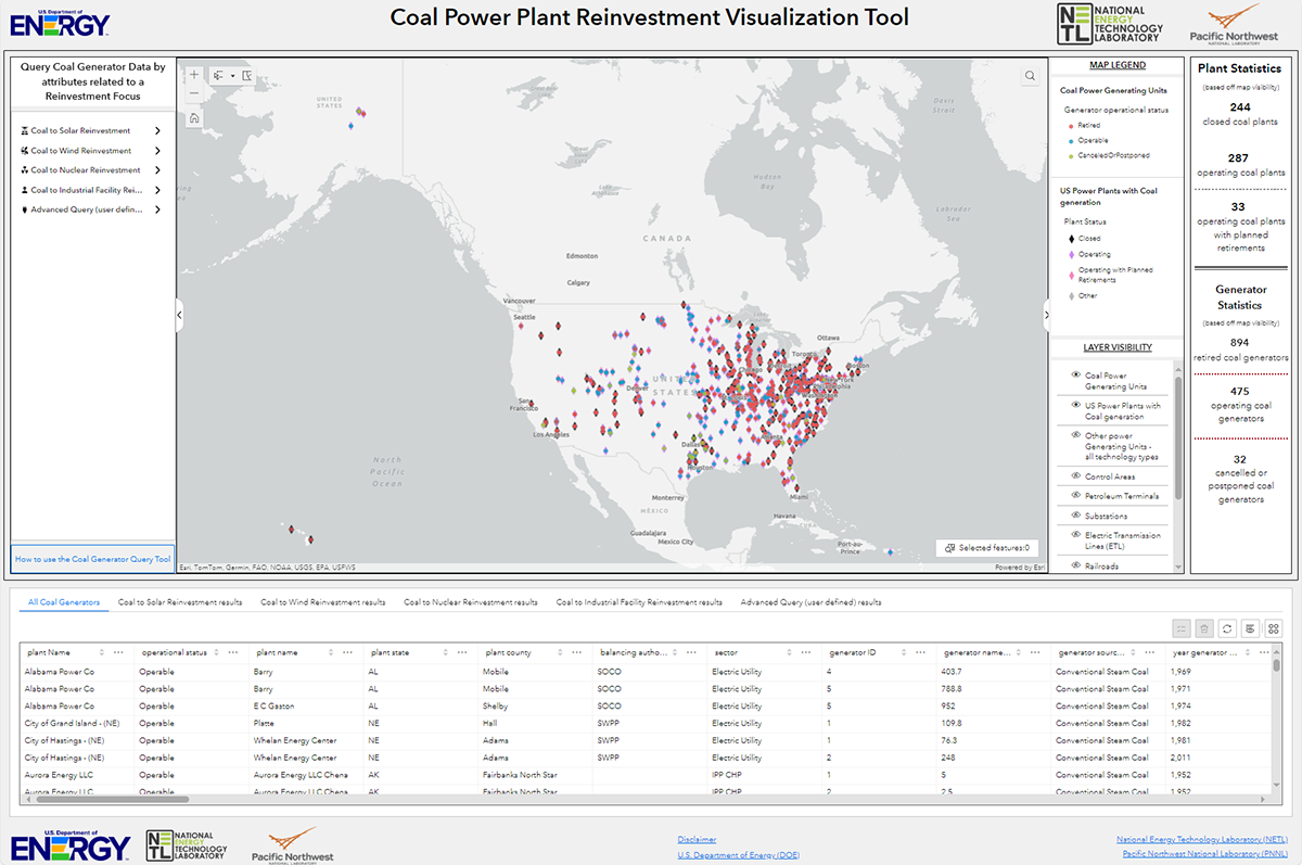
Geospatial NETLThis tool, available at https://energycommunities.gov/coal-power-plant-reinvestment-visualization-tool/, serves as a public database and map for the purposes of enabling state...
-
Dataset Size: 0 bytes
Resource List
View within Submission
Gathering Resources... -
-
Geospatial NETLThe Energy Community Atlas provides efficient access to authoritative, curated, and relevant data that is vital to supporting energy planning, development, and economic growth...
-
Dataset Size: 850.401 MB
Resource List
View within Submission
Gathering Resources... -
-
Geospatial NETLAn ArcGIS Story Map that provides context and understanding of unconventional critical mineral resource potential.
-
Dataset Size: 0 bytes
Resource List
View within Submission
Gathering Resources... -
-
AI/ML Geospatial NETLThe Advanced Infrastructure Integrity Model (AIIM) is a multivariate, multi-machine learning modeling technology applied to evaluate the integrity of offshore energy...
-
Dataset Size: 0 bytes
Resource List
View within Submission
Gathering Resources... -
-
Geospatial NETLThe CO2 Transport Planning Database v3.0 is a geospatial resource, containing over 70 gigabytes of data representing critical considerations for the spatial routing of pipelines...
-
Dataset Size: 112.597 GB
Resource List
View within Submission
Gathering Resources... -
-
NETLThis NRAP tool is for optimal design of microseismic monitoring network using surface or borehole geophones. User inputs include 1D/3D velocity models, the geophone distribution...
-
Dataset Size: 11.572 MB
Resource List
View within Submission
Gathering Resources... -
-
Geospatial NETLThis submission contains a zip file with the developed Global Oil & Gas Features Database (as an ArcGIS geodatabase). Access the technical report describing how this...
-
Dataset Size: 1.374 GB
Resource List
View within Submission
Gathering Resources... -
-
NETLCumulative Spatial Impact Layers™ (CSIL) is a GIS-based tool that summarizes spatio-temporal datasets based on overlapping features and attributes. Applying a recursive quadtree...
-
Dataset Size: 0 bytes
Resource List
View within Submission
Gathering Resources... -
-
GeospatialSocial vulnerability refers to the potential negative effects on communities caused by external stresses on human health. Such stresses include natural or human-caused...
-
Dataset Size: 0 bytes
Resource List
View within Submission
Gathering Resources... -
-
NETLThis tool evaluates the potential occurrence of URC resources using a series of validated heuristics as outlined in "Creason, C.G., Justman, D., Rose, K. et al. A Geo-Data...
-
Dataset Size: 360.817 MB
Resource List
View within Submission
Gathering Resources... -
-
Geospatial NETLThe Critical Minerals (CM) Data Dashboard provides data-driven insights to help unlock the potential of conventional and unconventional CM resources in the United States. The...
-
Dataset Size: 0 bytes
Resource List
View within Submission
Gathering Resources... -
-
Geospatial NETLNOTICE: Geocube has been replaced by EDX Spatial, a modern geospatial platform to map, visualize, query and explore spatial data. Online web mapping tool for visualization and...
-
Dataset Size: 0 bytes
Resource List
View within Submission
Gathering Resources... -
-
Geospatial NETLThe NEWTS (National Energy Water Treatment and Speciation) database dashboard displays sites across the nation where energy-related wastewater stream samples and composition...
-
Dataset Size: 0 bytes
Resource List
View within Submission
Gathering Resources... -
-
Geospatial NETLThis is the NETL Energy Data Exchange's platform for exploring , visualizing, and querying geospatial data. The EDX Spatial platform hosts web GIS layers, services, tools,...
-
Dataset Size: 0 bytes
Resource List
View within Submission
Gathering Resources... -
-
NETLThis tool contains functionality for estimating the storage potential of pure and blended natural gas-hydrogen mixtures in various subsurface formations and is intended to be...
-
Dataset Size: 0 bytes
Resource List
View within Submission
Gathering Resources... -
-
NETLData from Cravotta, Brady, "Priority pollutants and associated constituents in untreated and treated discharges from coal mining or processing facilities in Pennsylvania, USA"....
-
Dataset Size: 2.269 MB
Resource List
View within Submission
Gathering Resources... -
-
NETLThe Ocean & Geohazard Analysis (OGA) software tool is designed to summarize insights into key offshore hazards drawing from a diverse set of approaches, including artificial...
-
Dataset Size: 10.324 GB
Resource List
View within Submission
Gathering Resources... -
-
ScienceBase is an Open Source project that provides current documentation about its structure, information model, services, directory and repository. The wiki provides guidance...
-
Dataset Size: 0 bytes
Resource List
View within Submission
Gathering Resources... -